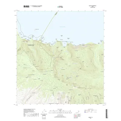
2017 Map of Kamalo
USGS Topo · Published 2017About this map
Kalaupapa National Historical Park dominates the northern coast of this island landscape, preserving the geography of the isolated peninsula and its surrounding sea cliffs. The terrain is defined by dramatic verticality, where numerous waterfalls such as Waimanu Falls, Wailele Falls, and Oloupena Falls plunge toward the Pacific Ocean. This 2017 survey details the complex system of gulches and ridges that separate the interior highlands from the coastal settlements. Evidence of local infrastructure is found in the Moloka'i Tunnel, which cuts through the volcanic rock, while sites like Kalawao Cem and the small coastal landing at Huelo mark significant historical points of human presence. The map illustrates a landscape where traditional names like Kamoku Flats and Pepe'opae persist alongside modern resource management boundaries.
Find a feature on this map
154 named features on this map. Tap any name to fly to it.
Don’t see what you’re looking for? This feature index may not catch every label — zoom into the map to look around manually.
Map Details
Editions of this 2017 Kamalo Map
This is the sole edition of this map. No revisions or reprints were ever made.
Other maps of this area

1952 · Halawa
USGS Topo · 1:24,000

1952 · Kamalo
USGS Topo · 1:24,000

1952 · Kaunakakai
USGS Topo · 1:24,000

1954 · Maui
USGS Topo · 1:250,000

1966 · Maui
USGS Topo · 1:250,000

1967 · Kaunakakai
USGS Topo · 1:24,000

1968 · Halawa
USGS Topo · 1:24,000
1968 · Kamalo
USGS Topo · 1:24,000

1974 · Maui
USGS Topo · 1:250,000
1983 · Molokai East
USGS Topo · 1:25,000