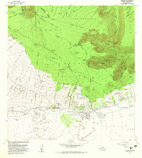
1982 Map of Kamuela
USGS Topo · Published 1982About this map
Waimea (Kamuela PO) serves as the inland hub of the South Kohala District in the early 1980s, positioned where the windswept grasslands of the high plateau meet the steep slopes of the Kohala Mountains. The landscape is defined by its ranching heritage and water management, visible through the extensive network of irrigation canals like the Upper Hamakua Ditch and the Lower Hamakua Ditch which trace the contours of the northeastern canyons.
Find a feature on this map
85 named features on this map. Tap any name to fly to it.
Don’t see what you’re looking for? This feature index may not catch every label — zoom into the map to look around manually.
Map Details
Editions of this 1982 Kamuela Map
This is the sole edition of this map. No revisions or reprints were ever made.
Other maps of this area

1913 · Kohala
USGS Topo · 1:62,500

1916 · Kohala
USGS Topo · 1:62,500

1916 · Waipio
USGS Topo · 1:62,500

1928 · Puako
USGS Topo · 1:62,500

1954 · Hawaii North
USGS Topo · 1:250,000

1956 · Puu Hinai
USGS Topo · 1:24,000

1956 · Kamuela
USGS Topo · 1:24,000

1956 · Nohonaohae
USGS Topo · 1:24,000

1956 · Makahalau
USGS Topo · 1:24,000

1956 · Kawaihae
USGS Topo · 1:24,000