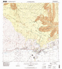
1995 Map of Kamuela
USGS Topo · Published 1998About this map
Waimea serves as the focal point of this mid-1990s survey, showing a landscape defined by ranching heritage and critical water management. The community of Kuhio Village and the Hawaii Prep Academy campus sit near the base of the Kohala Mountains, where the intricate engineering of the Upper Hamakua Ditch and Lower Hamakua Ditch systems move water through the high country. These waterworks, along with Waikoloa Reservoir No. 1 and Waikoloa Reservoir No. 2, illustrate the long-standing effort to harness the heavy rainfall of the Kohala Forest Reserve for the drier leeward slopes.
Find a feature on this map
53 named features on this map. Tap any name to fly to it.
Don’t see what you’re looking for? This feature index may not catch every label — zoom into the map to look around manually.
Map Details
Editions of this 1995 Kamuela Map
This is the sole edition of this map. No revisions or reprints were ever made.
Other maps of this area

1913 · Kohala
USGS Topo · 1:62,500

1916 · Kohala
USGS Topo · 1:62,500

1916 · Waipio
USGS Topo · 1:62,500

1928 · Puako
USGS Topo · 1:62,500

1954 · Hawaii North
USGS Topo · 1:250,000

1956 · Puu Hinai
USGS Topo · 1:24,000

1956 · Kamuela
USGS Topo · 1:24,000

1956 · Nohonaohae
USGS Topo · 1:24,000

1956 · Makahalau
USGS Topo · 1:24,000

1956 · Kawaihae
USGS Topo · 1:24,000