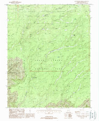
1988 Map of Kanabownits Spring
USGS Topo · Published 1988About this map
Kaibab National Forest and the Grand Canyon National Park meet in this 1980s topographical study of the North Rim, showing the transition from high-altitude timber to the dramatic erosional features of the canyon. A lone Lookout Tower stands above Kanabownits Spring and the Kanabownits Canyon floor, marking a critical observation point in the Grand Canyon National Game Preserve. The landscape is defined by vast depressions and sheer drops like the Shinumo Amphitheater and Gawain Abyss. Prominent overlooks including Galahad Point and Bedivere Point offer views over the Walla Valley and the complex drainage systems of Crystal Creek and Dragon Creek. The map documents the intricate network of canyons, from South Fork Canyon to Big Spring Canyon, illustrating the remote wilderness character of Coconino County before modern shifts in park management.
Find a feature on this map
31 named features on this map. Tap any name to fly to it.
Don’t see what you’re looking for? This feature index may not catch every label — zoom into the map to look around manually.
Map Details
Editions of this 1988 Kanabownits Spring Map
This is the sole edition of this map. No revisions or reprints were ever made.
Other maps of this area

1886 · Kaibab
USGS Topo · 1:250,000

1903 · Bright Angel
USGS Topo · 1:48,000

1906 · Bright Angel
USGS Topo · 1:48,000

1953 · Grand Canyon
USGS Topo · 1:250,000

1957 · Grand Canyon
USGS Topo · 1:250,000

1958 · Grand Canyon
USGS Topo · 1:250,000

1960 · Grand Canyon
USGS Topo · 1:250,000

1962 · Bright Angel
USGS Topo · 1:48,000

1962 · De Motte Park
USGS Topo · 1:62,500

1962 · Havasupai Point
USGS Topo · 1:62,500