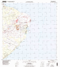
1995 Map of Kapoho
USGS Topo · Published 1998About this map
The volcanic landscape of the East Rift Zone dominates this coastal survey, where the physical geography is defined by successive layers of history. Significant geological events are marked by the Lava Flow of 1840, the Lava Flow of 1955, and the more recent Lava Flow of 1960, which shaped the coastline around Cape Kumukahi. Near the summit of Kapoho Crater, the presence of Green Lake and the settlement of Kapoho provide a stark contrast to the surrounding fields of cinder and stone. Along the shore, the U S Coast Guard Reservation stands at the easternmost point of the island, while the coastal reaches include Isaac Hale Park and the Mackenzie State Recreation Area. Smaller sites like Koa (Site) and various cemeteries offer touchpoints for genealogists researching family lands and heritage in this dynamic environment.
Find a feature on this map
57 named features on this map. Tap any name to fly to it.
Don’t see what you’re looking for? This feature index may not catch every label — zoom into the map to look around manually.
Map Details
Editions of this 1995 Kapoho Map
3 editions found
Other maps of this area

1924 · Makuu
USGS Topo · 1:62,500

1924 · Kalapana
USGS Topo · 1:62,500

1954 · Hawaii South
USGS Topo · 1:250,000

1954 · Hawaii North
USGS Topo · 1:250,000

1959 · Hawaii South
USGS Topo · 1:250,000

1959 · Hawaii North
USGS Topo · 1:250,000

1961 · Hawaii North
USGS Topo · 1:250,000

1961 · Hawaii South
USGS Topo · 1:250,000

1962 · Hawaii South
USGS Topo · 1:250,000
1965 · Pahoa North
USGS Topo · 1:24,000