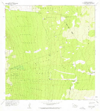
1960 Map of Kaunene
USGS Topo · Published 1961About this map
The Honaunau Forest Reserve dominates this upland landscape on the Island of Hawaii, where the terrain is marked by land divisions or ahupuaʻa extending from the slopes of Mauna Loa. These divisions, including Kealakekua, Keei 1, and Honaunau, reflect the traditional Hawaiian land management system still visible in the mid-century. Human activity is concentrated around specialized outposts such as Gaspars Dairy and the isolated Hapuu Camp. Water management in this high-elevation environment is evidenced by several Rain Sheds, a Gaging Sta, and the Komakawai Waterholes. An extensive network of Jeep Trails provides the primary means of navigating the interior, connecting remote landmarks like Puu Kinikini and Keanapaakai while crossing the district boundaries of North Kona, South Kona, and Kau.
Find a feature on this map
31 named features on this map. Tap any name to fly to it.
Don’t see what you’re looking for? This feature index may not catch every label — zoom into the map to look around manually.
Map Details
Editions of this 1960 Kaunene Map
2 editions found
Other maps of this area

1927 · Kaohe
USGS Topo · 1:62,500

1928 · Kailua
USGS Topo · 1:62,500

1928 · Mauna Loa
USGS Topo · 1:62,500

1930 · Kaohe
USGS Topo · 1:62,500

1954 · Hawaii South
USGS Topo · 1:250,000

1954 · Hawaii North
USGS Topo · 1:250,000

1956 · Puu O Uo
USGS Topo · 1:24,000

1959 · Hawaii South
USGS Topo · 1:250,000

1959 · Hawaii North
USGS Topo · 1:250,000

1959 · Honaunau
USGS Topo · 1:24,000