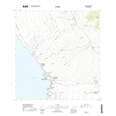
2017 Map of Kawaihae
USGS Topo · Published 2017About this map
Puukohola Heiau National Historic Site anchors the coastline of this South Kohala landscape, where ancient Hawaiian history meets modern military and ranching infrastructure. The coastal corridor is defined by the Ala Kahakai National Historic Trail winding past Kawaihae Bay and several distinct beaches such as Ohaiula Beach and Mauumae Beach. Rising from the shore toward the Kohala Mountains, the terrain is deeply incised by numerous gulches including Pohakuloa Gulch and Keauewai Gulch.
Find a feature on this map
91 named features on this map. Tap any name to fly to it.
Don’t see what you’re looking for? This feature index may not catch every label — zoom into the map to look around manually.
Map Details
Editions of this 2017 Kawaihae Map
This is the sole edition of this map. No revisions or reprints were ever made.
Other maps of this area

1913 · Kohala
USGS Topo · 1:62,500

1916 · Kohala
USGS Topo · 1:62,500

1916 · Waipio
USGS Topo · 1:62,500

1928 · Puako
USGS Topo · 1:62,500

1954 · Hawaii North
USGS Topo · 1:250,000

1956 · Puu Hinai
USGS Topo · 1:24,000

1956 · Kamuela
USGS Topo · 1:24,000

1956 · Nohonaohae
USGS Topo · 1:24,000

1956 · Kawaihae
USGS Topo · 1:24,000
1957 · Keawanui Bay
USGS Topo · 1:24,000