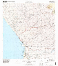
1995 Map of Kawaihae
USGS Topo · Published 1998About this map
Kawaihae serves as the focal point for this coastal survey of Hawaii's Kohala region, showing the infrastructure and landmarks that defined the shoreline in the late twentieth century. The map documents the Coast Guard Reservation and the Kawaihae Light standing near the harbor, while the nearby Puukohola Heiau National Historical Site marks a significant cultural landscape overlooking Kawaihae Bay. The inland terrain is characterized by a series of gulches and volcanic peaks, including Puu Pili and Puu Lapalapa, crisscrossed by numerous 4wd trails that provide access to the higher elevations.
Find a feature on this map
79 named features on this map. Tap any name to fly to it.
Don’t see what you’re looking for? This feature index may not catch every label — zoom into the map to look around manually.
Map Details
Editions of this 1995 Kawaihae Map
This is the sole edition of this map. No revisions or reprints were ever made.
Other maps of this area

1913 · Kohala
USGS Topo · 1:62,500

1916 · Kohala
USGS Topo · 1:62,500

1916 · Waipio
USGS Topo · 1:62,500

1928 · Puako
USGS Topo · 1:62,500

1954 · Hawaii North
USGS Topo · 1:250,000

1956 · Puu Hinai
USGS Topo · 1:24,000

1956 · Kamuela
USGS Topo · 1:24,000

1956 · Nohonaohae
USGS Topo · 1:24,000

1956 · Kawaihae
USGS Topo · 1:24,000
1957 · Keawanui Bay
USGS Topo · 1:24,000