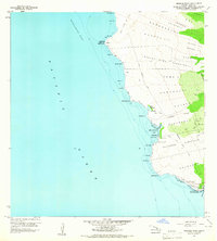
1959 Map of Keahole Point
USGS Topo · Published 1965About this map
The Lava Flow of 1801 dominates this arid coastal stretch of North Kona, creating a stark landscape where ancient Hawaiian sites meet mid-century development. Archaeological significance is evident throughout the terrain, with several temple sites including Ahuena Heiau, Hale o Mano Heiau, and Hale o Lono Heiau noted near the shoreline. Indigenous land use is further represented by the massive Kaloko Fishpond and various Petroglyphs found along the network of foot and pack trails.
Find a feature on this map
57 named features on this map. Tap any name to fly to it.
Don’t see what you’re looking for? This feature index may not catch every label — zoom into the map to look around manually.
Map Details
Editions of this 1959 Keahole Point Map
2 editions found
Other maps of this area

1928 · Puako
USGS Topo · 1:62,500

1928 · Kailua
USGS Topo · 1:62,500

1954 · Hawaii North
USGS Topo · 1:250,000

1959 · Hawaii North
USGS Topo · 1:250,000

1959 · Kiholo
USGS Topo · 1:24,000

1959 · Makalawena
USGS Topo · 1:24,000

1959 · Keahole Point
USGS Topo · 1:24,000

1959 · Kailua
USGS Topo · 1:24,000
1960 · Kealakekua
USGS Topo · 1:24,000

1961 · Hawaii North
USGS Topo · 1:250,000