1966 Map of Keams Canyon
USGS Topo · Published 1968About this map
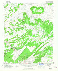
Keams Canyon serves as a primary hub within this high-desert landscape, situated along the Keams Canyon Wash at the foot of Antelope Mesa. The 1960s mapping detail shows the administrative and community infrastructure of the Hopi Indian Reservation, including a Radio Facility, a Trading Post, and the Kit Carson Inscription Picnic Area. To the north, the terrain transitions into the Navajo and Hopi Joint Use Area, where the settlement of Low Mountain sits near Polacca Wash.
Find a feature on this map
54 named features on this map. Tap any name to fly to it.
Don’t see what you’re looking for? This feature index may not catch every label — zoom into the map to look around manually.
Map Details
Editions of this 1966 Keams Canyon Map
This is the sole edition of this map. No revisions or reprints were ever made.
Other maps of this area

1883 · Marsh Pass
USGS Topo · 1:250,000

1883 · Tusayan
USGS Topo · 1:250,000

1886 · Tusayan
USGS Topo · 1:250,000

1886 · Fort Defiance
USGS Topo · 1:250,000

1892 · Fort Defiance
USGS Topo · 1:250,000

1892 · Marsh Pass
USGS Topo · 1:250,000

1892 · Canyon De Chelly
USGS Topo · 1:250,000

1947 · Flagstaff
USGS Topo · 1:250,000

1954 · Shiprock
USGS Topo · 1:250,000

1954 · Flagstaff
USGS Topo · 1:250,000
Featured Places
- Chinle Agency, AZ
- Fort Defiance Agency
- Keams Canyon, AZ
- Low Mountain, Fort Defiance Agency
- Nesuftanga, Fort Defiance Agency