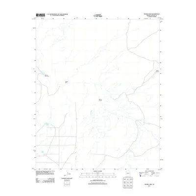
2011 Map of Kearn Lake
USGS Topo · Published 2011About this map
Kearn Lake sits at the northern end of a series of natural basins in this part of Apache County, where the landscape is defined by a network of drainage features and intermittent water sources. This 2011 survey details a region shaped by erosional patterns, with Marion Haws Draw and Aguaje Draw cutting across the terrain toward the larger Blanco Canyon. The southern portion of the sheet is marked by Big Lake and Boney Lake, which, along with the meandering Jarvis Wash, indicate the hydrology of this high-plateau environment. The arrangement of these features suggests a reliance on seasonal water flow in an area where topographical markers like Carrizo Wash serve as primary landmarks for orientation.
Find a feature on this map
8 named features on this map. Tap any name to fly to it.
Don’t see what you’re looking for? This feature index may not catch every label — zoom into the map to look around manually.
Map Details
Editions of this 2011 Kearn Lake Map
This is the sole edition of this map. No revisions or reprints were ever made.
Other maps of this area

1886 · St Johns
USGS Topo · 1:250,000

1892 · St Johns
USGS Topo · 1:250,000

1954 · Saint Johns
USGS Topo · 1:250,000

1957 · Saint Johns
USGS Topo · 1:250,000

1958 · Saint Johns
USGS Topo · 1:250,000

1962 · Saint Johns
USGS Topo · 1:250,000

1971 · Mesa Parada NW
USGS Topo · 1:24,000

1971 · Mesa Parada
USGS Topo · 1:24,000
1971 · St. Johns South
USGS Topo · 1:24,000
1974 · St. Johns North
USGS Topo · 1:24,000