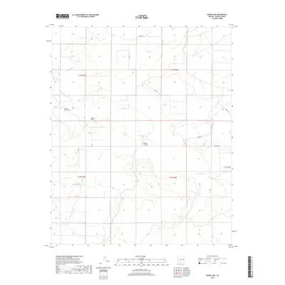
2018 Map of Kearn Lake
USGS Topo · Published 2018About this map
Kearn Lake and the surrounding high desert of Apache County are defined by a complex network of seasonal drainages and ephemeral water bodies. This 2018 survey documents a landscape of significant topographic relief, where the arid terrain is carved by features like Blanco Canyon and the expansive Marion Haws Draw. The map reveals the modern rural infrastructure of the region, where isolated residential corridors such as Serenity Ln and Holly Ln contrast with older, family-named landmarks like Dobie's Way. Hydrological patterns are central to the geography here, with Carrizo Wash and Aguaje Wash moving through the township boundaries of T14N and T13N. These washes, along with Boney Lake and Big Lake, suggest the importance of water management and natural catchments in this high-elevation Arizona environment.
Find a feature on this map
23 named features on this map. Tap any name to fly to it.
Don’t see what you’re looking for? This feature index may not catch every label — zoom into the map to look around manually.
Map Details
Editions of this 2018 Kearn Lake Map
This is the sole edition of this map. No revisions or reprints were ever made.
Other maps of this area

1886 · St Johns
USGS Topo · 1:250,000

1892 · St Johns
USGS Topo · 1:250,000

1954 · Saint Johns
USGS Topo · 1:250,000

1957 · Saint Johns
USGS Topo · 1:250,000

1958 · Saint Johns
USGS Topo · 1:250,000

1962 · Saint Johns
USGS Topo · 1:250,000

1971 · Mesa Parada NW
USGS Topo · 1:24,000

1971 · Mesa Parada
USGS Topo · 1:24,000
1971 · St. Johns South
USGS Topo · 1:24,000
1974 · St. Johns North
USGS Topo · 1:24,000