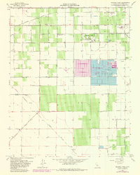
1963 Map of Kearney Park
USGS Topo · Published 1981About this map
The agrarian landscape of western Fresno County is defined by a dense grid of irrigation infrastructure and rural settlements during the early 1960s. Kearney Park (County) stands as a primary landmark, bordered by the Honor Farm and Houghton-Kearney Union School. The region's agricultural dependency is evidenced by the complex network of water features, including the Houghton Canal, Pacific Canal, and numerous unnamed ditches that feed the surrounding fields.
Find a feature on this map
65 named features on this map. Tap any name to fly to it.
Don’t see what you’re looking for? This feature index may not catch every label — zoom into the map to look around manually.
Map Details
Editions of this 1963 Kearney Park Map
2 editions found
Other maps of this area

1921 · Bullard
USGS Topo · 1:31,680

1923 · Kearney Park
USGS Topo · 1:31,680

1923 · Herndon
USGS Topo · 1:31,680

1923 · Fresno
USGS Topo · 1:31,680

1923 · Biola
USGS Topo · 1:31,680

1923 · Bullard
USGS Topo · 1:31,680

1925 · Helm
USGS Topo · 1:31,680

1925 · Raisin
USGS Topo · 1:31,680

1925 · Caruthers
USGS Topo · 1:31,680
1946 · Fresno South
USGS Topo · 1:24,000