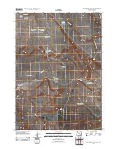
2011 Map of Keg Springs Valley East
USGS Topo · Published 2011About this map
Keg Springs Valley defines this arid landscape in Harney County, where water management is the primary human imprint on the terrain. The high desert environment is marked by a complex network of reservoirs and waterholes designed to capture seasonal runoff from drainages like Jackass Creek and Juniper Creek. Notable features include the Coyote Reservoir, Lower Herlihy Reservoir, and Upper Hawkins Reservoir in the north, while Barneys Butte stands as a prominent landmark in the west. The reliance on these intermittent sources is evident in the naming of sites like Twin Road Waterhole and Barneys Butte Waterhole. Access through this open range is provided by a sparse road network, including Jack Mountain Rd, which connects the various springs and catchments such as Keg Spring and Davies Spring.
Find a feature on this map
20 named features on this map. Tap any name to fly to it.
Don’t see what you’re looking for? This feature index may not catch every label — zoom into the map to look around manually.
Map Details
Editions of this 2011 Keg Springs Valley East Map
This is the sole edition of this map. No revisions or reprints were ever made.
Other maps of this area

1955 · Burns
USGS Topo · 1:250,000

1955 · Adel
USGS Topo · 1:250,000

1957 · Adel
USGS Topo · 1:250,000

1958 · Burns
USGS Topo · 1:250,000

1958 · Adel
USGS Topo · 1:250,000

1959 · Burns
USGS Topo · 1:250,000

1962 · Adel
USGS Topo · 1:250,000

1967 · Jackass Butte
USGS Topo · 1:24,000

1967 · Frenchglen
USGS Topo · 1:24,000
1967 · Irish Lake
USGS Topo · 1:24,000