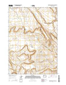
2014 Map of Keg Springs Valley East
USGS Topo · Published 2014About this map
Keg Springs Valley defines this high-desert basin in Harney County, where a complex network of water management features reveals the importance of ranching and irrigation in this arid landscape. Numerous man-made water sources, such as Lower Herlihy Reservoir, Upper Hawkins Reservoir, and Oscar Reservoir Number 4429, are situated across the terrain to capture seasonal runoff. These features, along with natural points like Davies Spring and Downs Lake, support a landscape largely devoid of permanent settlements but rich in named landmarks. The drainage of Jackass Cr and its southern fork cut through the eastern portion of the survey, while Barneys Butte stands as a prominent topographical marker to the southwest. Transport is limited to rugged tracks like Foster Lake Rd and Jack Mountain Rd, which provide access to this isolated portion of the Oregon desert.
Find a feature on this map
26 named features on this map. Tap any name to fly to it.
Don’t see what you’re looking for? This feature index may not catch every label — zoom into the map to look around manually.
Map Details
Editions of this 2014 Keg Springs Valley East Map
This is the sole edition of this map. No revisions or reprints were ever made.
Other maps of this area

1955 · Burns
USGS Topo · 1:250,000

1955 · Adel
USGS Topo · 1:250,000

1957 · Adel
USGS Topo · 1:250,000

1958 · Burns
USGS Topo · 1:250,000

1958 · Adel
USGS Topo · 1:250,000

1959 · Burns
USGS Topo · 1:250,000

1962 · Adel
USGS Topo · 1:250,000

1967 · Jackass Butte
USGS Topo · 1:24,000

1967 · Frenchglen
USGS Topo · 1:24,000
1967 · Irish Lake
USGS Topo · 1:24,000