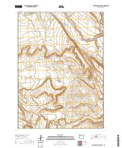
2020 Map of Keg Springs Valley East
USGS Topo · Published 2020About this map
Keg Springs Valley defines this high-desert landscape in Harney County, where water management is the primary imprint on the land. A complex network of catchments and reservoirs, such as the tiered Lower Herlihy, Middle Herlihy, and Upper Herlihy systems, illustrates the vital importance of irrigation and livestock watering in this arid region. These man-made features are joined by natural landmarks like Barneys Butte and the intermittent flows of Juniper Creek. The presence of the Foster Lake CCC Rd provides a historical link to New Deal-era infrastructure projects, showing how Civilian Conservation Corps routes continue to facilitate access through the sagebrush. From the Keg Springs Reservoir to the Bend in the Cr Spring Reservoir, the map reveals a terrain where every spring and drainage has been named and harnessed for local utility.
Find a feature on this map
26 named features on this map. Tap any name to fly to it.
Don’t see what you’re looking for? This feature index may not catch every label — zoom into the map to look around manually.
Map Details
Editions of this 2020 Keg Springs Valley East Map
This is the sole edition of this map. No revisions or reprints were ever made.
Other maps of this area

1955 · Burns
USGS Topo · 1:250,000

1955 · Adel
USGS Topo · 1:250,000

1957 · Adel
USGS Topo · 1:250,000

1958 · Burns
USGS Topo · 1:250,000

1958 · Adel
USGS Topo · 1:250,000

1959 · Burns
USGS Topo · 1:250,000

1962 · Adel
USGS Topo · 1:250,000

1967 · Jackass Butte
USGS Topo · 1:24,000

1967 · Frenchglen
USGS Topo · 1:24,000
1967 · Irish Lake
USGS Topo · 1:24,000