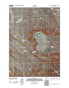
2011 Map of Keg Springs Valley West
USGS Topo · Published 2011About this map
Keg Springs Valley defines this high-desert landscape in Harney County, where water management is the primary signature on the land. In this 2011 survey, a network of isolated reservoirs and waterholes, such as the CCC Reservoir and Keg Springs Rimrock Reservoir, reveals the infrastructure necessary for ranching and resource management in this arid stretch of Oregon. The presence of Haines Cabin near Munsey Lake provides a rare point of named habitation in an area otherwise characterized by ephemeral water bodies like Camel Lake and Buckskin Lake.
Find a feature on this map
20 named features on this map. Tap any name to fly to it.
Don’t see what you’re looking for? This feature index may not catch every label — zoom into the map to look around manually.
Map Details
Editions of this 2011 Keg Springs Valley West Map
This is the sole edition of this map. No revisions or reprints were ever made.
Other maps of this area

1955 · Burns
USGS Topo · 1:250,000

1955 · Adel
USGS Topo · 1:250,000

1957 · Adel
USGS Topo · 1:250,000

1958 · Burns
USGS Topo · 1:250,000

1958 · Adel
USGS Topo · 1:250,000

1959 · Burns
USGS Topo · 1:250,000

1962 · Adel
USGS Topo · 1:250,000

1971 · Duhaime Flat East
USGS Topo · 1:24,000

1971 · Clover Swale
USGS Topo · 1:24,000
1971 · Keg Sprs Valley East
USGS Topo · 1:24,000