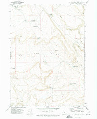
1971 Map of Keg Sprs Valley East
USGS Topo · Published 1974About this map
Keg Springs Valley dominates this high-desert landscape, reflecting a remote ranching and water-management system in southeastern Oregon. Cattle-rearing infrastructure is evident through the widespread network of reservoirs and springs, including the Lower Herlihy Reservoir and its associated upper and middle basins. The presence of the Well Corral and several waterholes, such as Twin Road Waterhole, highlights the essential need for water sources in this arid region of Harney County. Access to these areas is primarily limited to a network of a Jeep Trail and other unimproved tracks. Topographical landmarks like Barneys Butte and Jackass Butte provide significant vertical relief against the valley floor, while features like Downs Lake and Taylor Lake mark seasonal or perennial water basins critical to the local ecosystem during this era.
Find a feature on this map
23 named features on this map. Tap any name to fly to it.
Don’t see what you’re looking for? This feature index may not catch every label — zoom into the map to look around manually.
Map Details
Editions of this 1971 Keg Sprs Valley East Map
This is the sole edition of this map. No revisions or reprints were ever made.
Other maps of this area

1955 · Burns
USGS Topo · 1:250,000

1955 · Adel
USGS Topo · 1:250,000

1957 · Adel
USGS Topo · 1:250,000

1958 · Burns
USGS Topo · 1:250,000

1958 · Adel
USGS Topo · 1:250,000

1959 · Burns
USGS Topo · 1:250,000

1962 · Adel
USGS Topo · 1:250,000

1967 · Jackass Butte
USGS Topo · 1:24,000

1967 · Frenchglen
USGS Topo · 1:24,000
1967 · Irish Lake
USGS Topo · 1:24,000