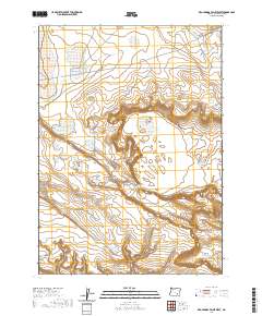
2020 Map of Keg Springs Valley West
USGS Topo · Published 2020About this map
Keg Springs Valley and the surrounding high desert of Harney County are defined by a complex network of ephemeral water sources and basins. This landscape reveals a history of water management in an arid environment, characterized by numerous man-made and natural catchments such as the Keg Springs Rimrock Reservoir, CCC Reservoir, and several named waterholes like Garry Lake Waterhole. The presence of the Foster Lake CCC Rd through Foster Flat indicates the legacy of Civilian Conservation Corps infrastructure projects that shaped this region's accessibility. Topographic features like Rocky Butte and the deep incision of V Canyon contrast with the broad, lake-dotted flats of Munsey Lake and Jerrys Lake, offering a detailed view of the drainage patterns and landforms in this remote section of southeastern Oregon.
Find a feature on this map
24 named features on this map. Tap any name to fly to it.
Don’t see what you’re looking for? This feature index may not catch every label — zoom into the map to look around manually.
Map Details
Editions of this 2020 Keg Springs Valley West Map
This is the sole edition of this map. No revisions or reprints were ever made.
Other maps of this area

1955 · Burns
USGS Topo · 1:250,000

1955 · Adel
USGS Topo · 1:250,000

1957 · Adel
USGS Topo · 1:250,000

1958 · Burns
USGS Topo · 1:250,000

1958 · Adel
USGS Topo · 1:250,000

1959 · Burns
USGS Topo · 1:250,000

1962 · Adel
USGS Topo · 1:250,000

1971 · Duhaime Flat East
USGS Topo · 1:24,000

1971 · Clover Swale
USGS Topo · 1:24,000
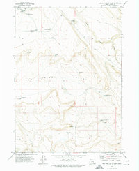
1971 · Keg Sprs Valley East
USGS Topo · 1:24,000