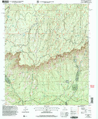
2004 Map of Kehl Ridge
USGS Topo · Published 2006About this map
Mogollon Rim dominates this central Arizona landscape, forming a dramatic escarpment that separates the Coconino National Forest to the north from the Tonto National Forest below. This survey captures the area during a period of sustained recreational and forest management, where the rugged terrain is accessed via the Control Road and historic paths like the Highline Trail and Geronimo Trail. Small enclaves of settlement appear near the base of the rim at Washington Park and the Rim Trail Mountain Club Estates, while the high country is dotted with essential water sources such as Potato Lake, Kehl Spring, and General Springs. The geography is defined by a series of north-south drainage patterns including Clover Canyon and Miller Canyon, which cut through elevated features like Kehl Ridge and Battleground Ridge. Traceable infrastructure includes a Pumpstation, a Gravel Pit, and various benchmarks marking high points like Baker Butte.
Find a feature on this map
67 named features on this map. Tap any name to fly to it.
Don’t see what you’re looking for? This feature index may not catch every label — zoom into the map to look around manually.
Map Details
Editions of this 2004 Kehl Ridge Map
This is the sole edition of this map. No revisions or reprints were ever made.
Other maps of this area

1887 · Verde
USGS Topo · 1:250,000

1892 · Verde
USGS Topo · 1:250,000

1934 · Pine
USGS Topo · 1:62,500

1934 · Promontory Butte
USGS Topo · 1:62,500

1939 · Promontory Butte
USGS Topo · 1:62,500

1940 · Pine
USGS Topo · 1:62,500

1952 · Pine
USGS Topo · 1:62,500

1952 · Promontory Butte
USGS Topo · 1:62,500

1954 · Holbrook
USGS Topo · 1:250,000

1957 · Holbrook
USGS Topo · 1:250,000
Featured Places
- Verde Glen, AZ
- Washington Park, AZ
- Rim Trail Mountain Club Estates, AZ
- Coconino County, AZ
- Gila County, AZ