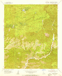
1953 Map of Keller Peak
USGS Topo · Published 1955About this map
Green Valley Lake and the high-elevation settlements of the San Bernardino National Forest appear here in a mid-century snapshot of California's mountain recreation culture. The map documents a dense network of institutional retreats and summer camps, including the Little Green Valley YMCA Boys Camp, Camp Cedar Crest, and Larrys Boys Camp. These mountain enclaves are concentrated around water features like Arrowbear Lake and the drainage of Deep Creek.
Find a feature on this map
45 named features on this map. Tap any name to fly to it.
Don’t see what you’re looking for? This feature index may not catch every label — zoom into the map to look around manually.
Map Details
Editions of this 1953 Keller Peak Map
2 editions found
Other maps of this area

1899 · Redlands
USGS Topo · 1:62,500

1901 · Southern California Sheet No. 1
USGS Topo · 1:250,000

1901 · Redlands
USGS Topo · 1:62,500

1902 · Deep Creek
USGS Topo · 1:62,500

1902 · San Gorgonio
USGS Topo · 1:125,000

1904 · Southern California Sheet No. 1
USGS Topo · 1:250,000

1947 · Lucerne Valley
USGS Topo · 1:62,500

1949 · Lucerne Valley
USGS Topo · 1:62,500

1953 · San Bernardino
USGS Topo · 1:250,000
1953 · Harrison Mtn.
USGS Topo · 1:24,000