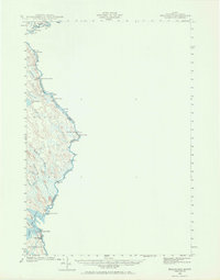
1940 Map of Kellyland
USGS Topo · Published 1969About this map
The St Croix River serves as the dominant spine of this borderland survey, marking the international boundary between Maine and New Brunswick. This 1940 record documents the hydrology of the river system before later development, capturing a sequence of navigational hazards including Tyler Rips, Meetinghouse Rips, and Canoose Rips. The lower portion of the map shows the industrial and settlement activity at Kellyland and within the town of Baileyville, situated near the significant water control points of Grand Falls and the Grand Falls Flowage. Interior wilderness reaches are defined by a network of drainage basins such as Catamount Brook and Millberry Brook, while small outposts like Crocker Camp appear along the riverbanks. The map's detailed contouring reveals the complex wetland environment of Haycook Bog and the isolated waters of Hound Brook Lake.
Find a feature on this map
28 named features on this map. Tap any name to fly to it.
Don’t see what you’re looking for? This feature index may not catch every label — zoom into the map to look around manually.
Map Details
Editions of this 1940 Kellyland Map
3 editions found
Other maps of this area

1929 · Calais
USGS Topo · 1:48,000

1929 · Robbinston
USGS Topo · 1:48,000

1930 · Vanceboro
USGS Topo · 1:48,000

1931 · Robbinston
USGS Topo · 1:62,500

1932 · Calais
USGS Topo · 1:62,500

1933 · Vanceboro
USGS Topo · 1:62,500

1940 · Waite
USGS Topo · 1:62,500

1940 · Forest
USGS Topo · 1:62,500

1940 · Kellyland
USGS Topo · 1:62,500

1941 · Big Lake
USGS Topo · 1:62,500