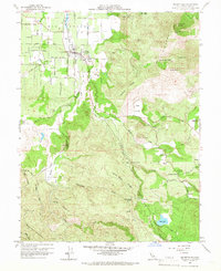
1959 Map of Kelseyville
USGS Topo · Published 1966About this map
Big Valley opens into a fertile agricultural landscape north of the prominent Kono Cti Mountain, where the settlement of Kelseyville serves as a central hub for the surrounding orchards and farms. This 1959 field-checked survey highlights the transition from the flat basin, marked by Loasa Road and Merritt Road, to the rising elevations of the Mayacmas Mountains and Bensen Ridge. The map identifies critical local infrastructure, including the Kelseyville High School and a Historical Marker near the town center, while showing the vital water network of Kelsey Creek and Cole Creek feeding the valley floor. To the south and east, the terrain becomes increasingly complex, featuring Boggs Lake and several remote springs like Carlsbad Spring and Poison Smith Spring, which underscore the geological character of the region near Soda Bay.
Find a feature on this map
44 named features on this map. Tap any name to fly to it.
Don’t see what you’re looking for? This feature index may not catch every label — zoom into the map to look around manually.
Map Details
Editions of this 1959 Kelseyville Map
Other maps of this area

1921 · Kelseyville
USGS Topo · 1:62,500

1924 · Bartlett Springs
USGS Topo · 1:62,500

1938 · Lakeport
USGS Topo · 1:62,500

1942 · Bartlett Springs
USGS Topo · 1:62,500

1943 · Kelseyville
USGS Topo · 1:62,500

1944 · Bartlett Springs
USGS Topo · 1:62,500

1945 · Lower Lake
USGS Topo · 1:62,500

1947 · Santa Rosa
USGS Topo · 1:250,000

1949 · Santa Rosa
USGS Topo · 1:250,000

1951 · Lakeport
USGS Topo · 1:62,500