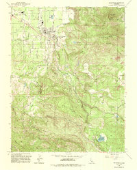
1993 Map of Kelseyville
USGS Topo · Published 1993About this map
Big Valley agriculture and the volcanic slopes of the Mayacmas Mountains define this landscape south of Soda Bay. The town of Kelseyville serves as the central hub, surrounded by orchards and vineyards that depend on the drainage of Kelsey Creek and Adobe Creek. As the terrain rises toward the east, the map reveals the complex topography of Mount Konocti, featuring prominent landmarks like Wright Peak and its Lookout Tower. This 1993 edition highlights the area's transition into energy production and conservation, marked by the presence of Geothermal Wells and the protected waters of Boggs Lake within the Boggs Lake Preserve. From the High Sch in town to the remote Carlsbad Spring, the map documents a community balancing its established farming roots with specialized geological interests and recreation near Clear Lake State Park.
Find a feature on this map
54 named features on this map. Tap any name to fly to it.
Don’t see what you’re looking for? This feature index may not catch every label — zoom into the map to look around manually.
Map Details
Editions of this 1993 Kelseyville Map
This is the sole edition of this map. No revisions or reprints were ever made.
Other maps of this area

1921 · Kelseyville
USGS Topo · 1:62,500

1924 · Bartlett Springs
USGS Topo · 1:62,500

1938 · Lakeport
USGS Topo · 1:62,500

1942 · Bartlett Springs
USGS Topo · 1:62,500

1943 · Kelseyville
USGS Topo · 1:62,500

1944 · Bartlett Springs
USGS Topo · 1:62,500

1945 · Lower Lake
USGS Topo · 1:62,500

1947 · Santa Rosa
USGS Topo · 1:250,000

1949 · Santa Rosa
USGS Topo · 1:250,000

1951 · Lakeport
USGS Topo · 1:62,500