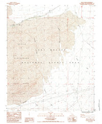
1984 Map of Kelso Dunes
USGS Topo · Published 1985About this map
Kelso and the nearby Flynn Siding sit at the northern edge of this high-desert landscape, serving the Union Pacific railroad corridor. The area is dominated by the shifting sands of the Kelso Dunes and the expansive Devils Playground, which are preserved within the East Mojave National Scenic Area. This 1980s-era documentation reflects the remote infrastructure of the Mojave, showing the Kelbaker Road and Vulcan Mine Road as primary access points through the wash-streaked terrain.
Find a feature on this map
20 named features on this map. Tap any name to fly to it.
Don’t see what you’re looking for? This feature index may not catch every label — zoom into the map to look around manually.
Map Details
Editions of this 1984 Kelso Dunes Map
2 editions found
Other maps of this area

1910 · Ivanpah
USGS Topo · 1:250,000

1912 · Ivanpah
USGS Topo · 1:250,000

1942 · Ivanpah
USGS Topo · 1:250,000

1942 · Amboy
USGS Topo · 1:250,000

1943 · Amboy
USGS Topo · 1:250,000

1947 · Kingman
USGS Topo · 1:250,000

1948 · Kingman
USGS Topo · 1:250,000

1954 · Needles
USGS Topo · 1:250,000

1954 · Kingman
USGS Topo · 1:250,000

1955 · Kingman
USGS Topo · 1:250,000