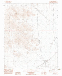
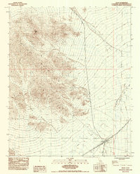
1983 Map of Kelso
USGS Topo · Published 1983About this map
The Union Pacific railroad corridor anchors this high desert landscape in San Bernardino County, where the small settlement of Kelso serves as a vital infrastructure hub. The map captures the meeting point of desert transport and industrial history, showing the railroad tracks flanked by Water Tanks and a Cem nearby. To the west, the Kelso Mountains rise dramatically, topped by Kelso Peak, while the broad expanse of the Kelso Wash cuts through the alluvial plains.
Find a feature on this map
17 named features on this map. Tap any name to fly to it.
Don’t see what you’re looking for? This feature index may not catch every label — zoom into the map to look around manually.
Map Details
Editions of this 1983 Kelso Map
2 editions found
Other maps of this area

1910 · Ivanpah
USGS Topo · 1:250,000

1912 · Ivanpah
USGS Topo · 1:250,000

1942 · Ivanpah
USGS Topo · 1:250,000

1942 · Amboy
USGS Topo · 1:250,000

1943 · Amboy
USGS Topo · 1:250,000

1947 · Kingman
USGS Topo · 1:250,000

1948 · Kingman
USGS Topo · 1:250,000

1954 · Needles
USGS Topo · 1:250,000

1954 · Kingman
USGS Topo · 1:250,000

1955 · Kingman
USGS Topo · 1:250,000