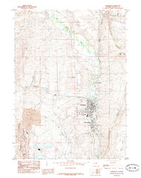
1985 Map of Kemmerer
USGS Topo · Published 1985About this map
Kemmerer and Diamondville anchor this mid-1980s landscape, illustrating the industrial and transport identity of Lincoln County. The Hams Fork winds southward past Frontier, providing the geographic spine for these settlements as they expanded along the river valley. The region's connection to heavy industry is prominent, marked by the massive Power Plant to the south and numerous Transmission Lines spider-webbing across the terrain.
Find a feature on this map
32 named features on this map. Tap any name to fly to it.
Don’t see what you’re looking for? This feature index may not catch every label — zoom into the map to look around manually.
Map Details
Editions of this 1985 Kemmerer Map
This is the sole edition of this map. No revisions or reprints were ever made.
Other maps of this area

1954 · Ogden
USGS Topo · 1:250,000

1954 · Kemmerer
USGS Topo · 1:62,500

1958 · Ogden
USGS Topo · 1:250,000

1960 · Ogden
USGS Topo · 1:250,000

1962 · Elkol
USGS Topo · 1:24,000

1962 · Warfield Creek
USGS Topo · 1:24,000

1969 · Willow Springs
USGS Topo · 1:24,000
1969 · Round Mountain
USGS Topo · 1:24,000
1969 · Little Round Mountain
USGS Topo · 1:24,000
1979 · Kemmerer
USGS Topo · 1:100,000