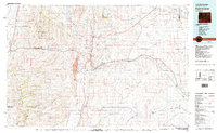
1979 Map of Kemmerer
USGS Topo · Published 1995About this map
Kemmerer and its neighboring towns of Diamondville and Frontier serve as the focal point of this late-1970s landscape, illustrating a region defined by its energy production and fossil heritage. The Elkol Strip Mine and the nearby Brilliant No 8 Mine indicate the heavy industrial activity south of the city, while the Fossil Butte National Monument preserves the area's deeper geological history to the west.
Find a feature on this map
67 named features on this map. Tap any name to fly to it.
Don’t see what you’re looking for? This feature index may not catch every label — zoom into the map to look around manually.
Map Details
Editions of this 1979 Kemmerer Map
2 editions found
Other maps of this area

1909 · Montpelier
USGS Topo · 1:125,000

1911 · Montpelier
USGS Topo · 1:125,000

1912 · Randolph
USGS Topo · 1:125,000

1936 · Cokeville
USGS Topo · 1:96,000

1942 · Cokeville
USGS Topo · 1:125,000

1945 · Fort Hill
USGS Topo · 1:62,500

1947 · Fort Hill
USGS Topo · 1:62,500

1954 · Sage
USGS Topo · 1:62,500

1954 · Ogden
USGS Topo · 1:250,000

1954 · Rock Springs
USGS Topo · 1:250,000