
1954 Map of Sage
USGS Topo · Published 1956About this map
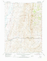
Bear River dominates the western landscape of this mid-century Lincoln County survey, winding through a valley shaped by early irrigation infrastructure like the Pixley Ditch and Mc Farlane Ditch. The presence of a small Cem near the settlement of Leefe and the tight clustering of stations such as Pixley, Beckwith, and Carlson along the Union Pacific line illustrate the region's reliance on rail transport for its agricultural and ranching economy.
Find a feature on this map
43 named features on this map. Tap any name to fly to it.
Don’t see what you’re looking for? This feature index may not catch every label — zoom into the map to look around manually.
Map Details
Editions of this 1954 Sage Map
2 editions found
Other maps of this area

1909 · Montpelier
USGS Topo · 1:125,000

1911 · Montpelier
USGS Topo · 1:125,000

1912 · Randolph
USGS Topo · 1:125,000

1936 · Cokeville
USGS Topo · 1:96,000

1942 · Cokeville
USGS Topo · 1:125,000

1954 · Ogden
USGS Topo · 1:250,000

1954 · Kemmerer
USGS Topo · 1:62,500

1955 · Preston
USGS Topo · 1:250,000

1958 · Ogden
USGS Topo · 1:250,000

1958 · Preston
USGS Topo · 1:250,000