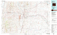
1979 Map of Kemmerer
USGS Topo · Published 1980About this map
Fossil Butte National Monument anchors the high desert landscape of Lincoln County, revealing the paleontological and geological layers of the Green River Formation. This 1979 survey captures the regional energy and transportation nexus centered on the mining town of Kemmerer and neighboring Diamondville. The industrial footprint of the Elkol Strip Mine is prominently marked against the Cumberland Flats, while the Union Pacific railroad tracks and Us 30 facilitate movement through the mountain gaps. From the narrow settlements of Frontier and Sage to the wide drainages of the Bear River and Hams Fork, the map illustrates a landscape defined by sharp ridges like Commissary Ridge and the vital water resources required for development in the Wyoming high country.
Find a feature on this map
36 named features on this map. Tap any name to fly to it.
Don’t see what you’re looking for? This feature index may not catch every label — zoom into the map to look around manually.
Map Details
Editions of this 1979 Kemmerer Map
2 editions found
Other maps of this area

1909 · Montpelier
USGS Topo · 1:125,000

1911 · Montpelier
USGS Topo · 1:125,000

1912 · Randolph
USGS Topo · 1:125,000

1936 · Cokeville
USGS Topo · 1:96,000

1942 · Cokeville
USGS Topo · 1:125,000

1945 · Fort Hill
USGS Topo · 1:62,500

1947 · Fort Hill
USGS Topo · 1:62,500

1954 · Sage
USGS Topo · 1:62,500

1954 · Ogden
USGS Topo · 1:250,000

1954 · Rock Springs
USGS Topo · 1:250,000