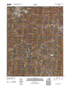
2010 Map of Kenbridge West
USGS Topo · Published 2010About this map
Victoria and Kenbridge anchor this portion of the Virginia piedmont, where the landscape is defined by the winding paths of Big Hounds Creek and Flat Rock Creek. The area maintains a rural character punctuated by local infrastructure like the Lunenburg County Airport and the Victoria Post Office. Water management is prominent throughout the region, seen in the Lunenburg Beach Reservoir and several small-scale impoundments such as Marshall Dam, Kenbridge Dam, and Sneads Dam.
Find a feature on this map
24 named features on this map. Tap any name to fly to it.
Don’t see what you’re looking for? This feature index may not catch every label — zoom into the map to look around manually.
Map Details
Editions of this 2010 Kenbridge West Map
This is the sole edition of this map. No revisions or reprints were ever made.
Other maps of this area

1891 · Farmville
USGS Topo · 1:125,000

1893 · Farmville
USGS Topo · 1:125,000

1947 · Roanoke
USGS Topo · 1:250,000

1953 · Greensboro
USGS Topo · 1:250,000

1954 · Greensboro
USGS Topo · 1:250,000

1955 · Chase City
USGS Topo · 1:62,500

1955 · Kenbridge
USGS Topo · 1:62,500

1958 · Crewe
USGS Topo · 1:62,500

1958 · Keysville
USGS Topo · 1:62,500

1959 · Roanoke
USGS Topo · 1:250,000