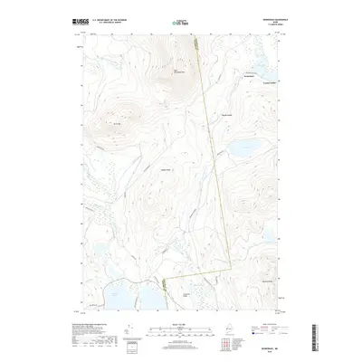
2018 Map of Kennebago
USGS Topo · Published 2018About this map
Kennebago and Grants Camps sit nestled at the edge of Kennebago Lake in this high-country landscape along the Franklin Co and Oxford Co border. The map reveals a network of waterways and ridges defining the Maine wilderness, from the peaks of West Kennebago Mtn and Burnt Mtn to the southern shores of Cupsuptic Lake. A notable industrial artifact is the Abandoned Rail Rd south of Cloutman Ridge, indicating the region's historic connection to timber harvesting and rail transport. The map also traces various woods roads such as Tim Pond Rd and Kennebago River Rd, which follow the natural contours of the Kennebago River valley. Smaller water bodies like Johns Pond and Mud Pond are scattered throughout the interior, alongside local landmarks like Daddys Ridge and Ephraim Ridge.
Find a feature on this map
36 named features on this map. Tap any name to fly to it.
Don’t see what you’re looking for? This feature index may not catch every label — zoom into the map to look around manually.
Map Details
Editions of this 2018 Kennebago Map
This is the sole edition of this map. No revisions or reprints were ever made.
Other maps of this area

1931 · Cupsuptic
USGS Topo · 1:48,000

1932 · Kennebago Lake
USGS Topo · 1:48,000

1933 · Rangeley
USGS Topo · 1:48,000

1934 · Cupsuptic
USGS Topo · 1:62,500

1935 · Kennebago Lake
USGS Topo · 1:62,500

1935 · Cupsuptic
USGS Topo · 1:62,500

1936 · Kennebago Lake
USGS Topo · 1:62,500

1939 · Rangeley
USGS Topo · 1:62,500

1940 · Oquossoc
USGS Topo · 1:62,500

1942 · Oquossoc
USGS Topo · 1:62,500
Featured Places
- Rangeley, ME
- Adamstown Township, ME
- Davis Town, Davis Township
- Stetsontown Township, ME
- Davis Township, ME