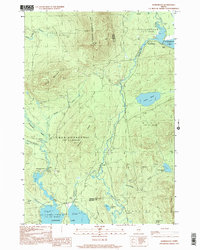
1997 Map of Kennebago
USGS Topo · Published 2000About this map
Kennebago Lake and the winding course of the Kennebago River dominate this rugged section of the Maine north woods at the turn of the millennium. The landscape is defined by vast timberlands and sporting traditions, evidenced by the presence of Grants Camps on the eastern shore and the remote Moochers Home near Little Falls. Significant topographical features like West Kennebago Mountain, which is capped by a Lookout Tower, and Burnt Mountain overlook a complex network of brooks and ponds including Johns Pond and Kamankeag Pond. This survey captures the region just as it remained a stronghold for traditional wilderness recreation, with numerous gravel pits scattered across the terrain indicating the ongoing maintenance of the logging road networks that provide the only land access to these remote waters. The map also delineates the civil boundaries of townships such as Stetsontown and Adamstown.
Find a feature on this map
36 named features on this map. Tap any name to fly to it.
Don’t see what you’re looking for? This feature index may not catch every label — zoom into the map to look around manually.
Map Details
Editions of this 1997 Kennebago Map
This is the sole edition of this map. No revisions or reprints were ever made.
Other maps of this area

1931 · Cupsuptic
USGS Topo · 1:48,000

1932 · Kennebago Lake
USGS Topo · 1:48,000

1933 · Rangeley
USGS Topo · 1:48,000

1934 · Cupsuptic
USGS Topo · 1:62,500

1935 · Kennebago Lake
USGS Topo · 1:62,500

1935 · Cupsuptic
USGS Topo · 1:62,500

1936 · Kennebago Lake
USGS Topo · 1:62,500

1939 · Rangeley
USGS Topo · 1:62,500

1940 · Oquossoc
USGS Topo · 1:62,500

1942 · Oquossoc
USGS Topo · 1:62,500
Featured Places
- Rangeley, ME
- Adamstown Township, ME
- Stetsontown Township, ME
- Lower Cupsuptic Township, ME
- Kennebago, Stetsontown Township