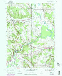
1954 Map of Kennedy
USGS Topo · Published 1980About this map
Conewango Creek dominates the valley floor in this mid-century survey, its winding course threading between the hills of Chautauqua and Cattaraugus Counties. The landscape is a mix of agricultural bottoms and upland ridges, with several historic burial grounds such as Pioneer Cem and Little Clear Creek Cem marking the early settlement of the area. The rail corridor, operated by Conrail at the time of this update, connects the local economies of Kennedy, Conewango, and Randolph. Small hamlets and named intersections like Schermerhorn Corners and Waterboro offer a window into the rural layout of Western New York, while the presence of Randolph Airport and numerous local roads like Wade Road and Dailey Road illustrate the evolving transportation network through the Ellington and Poland townships.
Find a feature on this map
43 named features on this map. Tap any name to fly to it.
Don’t see what you’re looking for? This feature index may not catch every label — zoom into the map to look around manually.
Map Details
Editions of this 1954 Kennedy Map
3 editions found
Other maps of this area

1900 · Cherry Creek
USGS Topo · 1:62,500

1905 · Jamestown
USGS Topo · 1:62,500

1922 · Randolph
USGS Topo · 1:62,500

1923 · Randolph
USGS Topo · 1:62,500

1923 · Cattaraugus
USGS Topo · 1:62,500

1938 · Cattaraugus
USGS Topo · 1:62,500

1941 · Cattaraugus
USGS Topo · 1:62,500

1941 · Cherry Creek
USGS Topo · 1:62,500

1942 · Jamestown
USGS Topo · 1:62,500

1943 · Randolph
USGS Topo · 1:62,500