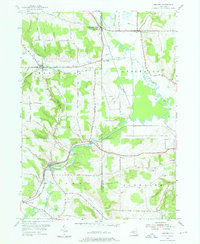
1954 Map of Kennedy
USGS Topo · Published 1976About this map
Conewango Creek carves a winding path through the borderlands of Chautauqua and Cattaraugus Counties, defining the agricultural and industrial character of the region during the mid-1950s. The Erie RR serves as a primary transit corridor, linking settlements like Kennedy and Waterboro while mirroring the path of the valley floor. The map documents a landscape of established family farms and small hamlets, with distinctive local names such as Schermerhorn Corners and Bowen marking the intersections of rural life.
Find a feature on this map
48 named features on this map. Tap any name to fly to it.
Don’t see what you’re looking for? This feature index may not catch every label — zoom into the map to look around manually.
Map Details
Editions of this 1954 Kennedy Map
3 editions found
Other maps of this area

1900 · Cherry Creek
USGS Topo · 1:62,500

1905 · Jamestown
USGS Topo · 1:62,500

1922 · Randolph
USGS Topo · 1:62,500

1923 · Randolph
USGS Topo · 1:62,500

1923 · Cattaraugus
USGS Topo · 1:62,500

1938 · Cattaraugus
USGS Topo · 1:62,500

1941 · Cattaraugus
USGS Topo · 1:62,500

1941 · Cherry Creek
USGS Topo · 1:62,500

1942 · Jamestown
USGS Topo · 1:62,500

1943 · Randolph
USGS Topo · 1:62,500