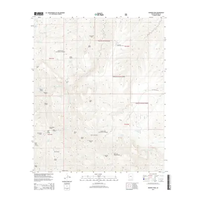
2014 Map of Kennedy Peak
USGS Topo · Published 2014About this map
Kennedy Peak and Rockhouse Peak anchor this high-elevation terrain within the Coronado National Forest, where the complex drainage systems of the Galiuro Mountains are mapped in detail. The landscape is defined by a network of steep canyons such as Pipestem Canyon and Mailbox Canyon, leading down toward the southern course of Paddys River. Notable for its remote utility, the China Peak Observatory Airport sits atop a ridge near China Peak, overlooking the Rattlesnake Mesa to the north. Water sources are critical landmarks in this arid environment, evidenced by named features like Powers Garden Spring, Willow Spring, and Bluff Spring. These points of interest, along with the various cattle tanks like Peach Tree Tank, illustrate the intersection of conservation land, high-altitude research infrastructure, and the historical reliance on isolated water improvements for ranching and forest management.
Find a feature on this map
53 named features on this map. Tap any name to fly to it.
Don’t see what you’re looking for? This feature index may not catch every label — zoom into the map to look around manually.
Map Details
Editions of this 2014 Kennedy Peak Map
This is the sole edition of this map. No revisions or reprints were ever made.
Other maps of this area

1938 · Galiuro Mts
USGS Topo · 1:48,000

1938 · Klondyke
USGS Topo · 1:48,000

1940 · Sierra Bonita Ranch
USGS Topo · 1:62,500

1942 · Sierra Bonita Ranch
USGS Topo · 1:62,500

1943 · Galiuro Mts
USGS Topo · 1:62,500

1943 · Klondyke
USGS Topo · 1:62,500

1943 · Sierra Bonita Ranch
USGS Topo · 1:62,500

1944 · Jackson Mtn.
USGS Topo · 1:62,500

1946 · Jackson Mtn.
USGS Topo · 1:62,500

1956 · Tucson
USGS Topo · 1:250,000