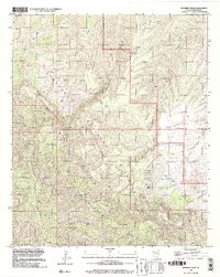
1996 Map of Kennedy Peak
USGS Topo · Published 2002About this map
The Galiuro Wilderness defines this high-elevation landscape within the Coronado National Forest, where steep canyons and sharp peaks dominate the geography. Scientific and ranching interests coexist in this remote terrain, marked by the presence of the China Peak Observatory atop China Peak and several established outposts like the Deer Creek Ranch and Eureka Ranch. The map captures a sophisticated network of pack trails, including the Powers Pack Trail and Horse Pack Trail, which were essential for navigating the complex drainage systems of Rattlesnake Canyon and Sycamore Canyon. Names like Powers Garden and Home Ranch Tank suggest a history of localized water management and settlement in an otherwise demanding environment, while the peak of Kennedy Peak stands as a primary landmark in the southern reaches of the range.
Find a feature on this map
54 named features on this map. Tap any name to fly to it.
Don’t see what you’re looking for? This feature index may not catch every label — zoom into the map to look around manually.
Map Details
Editions of this 1996 Kennedy Peak Map
This is the sole edition of this map. No revisions or reprints were ever made.
Other maps of this area

1938 · Galiuro Mts
USGS Topo · 1:48,000

1938 · Klondyke
USGS Topo · 1:48,000

1940 · Sierra Bonita Ranch
USGS Topo · 1:62,500

1942 · Sierra Bonita Ranch
USGS Topo · 1:62,500

1943 · Galiuro Mts
USGS Topo · 1:62,500

1943 · Klondyke
USGS Topo · 1:62,500

1943 · Sierra Bonita Ranch
USGS Topo · 1:62,500

1944 · Jackson Mtn.
USGS Topo · 1:62,500

1946 · Jackson Mtn.
USGS Topo · 1:62,500

1956 · Tucson
USGS Topo · 1:250,000