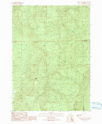
1990 Map of Kenyon Mountain
USGS Topo · Published 1990About this map
Radio Facility Camas Lookout stands as a prominent point of interest in this forested expanse of the Oregon Coast Range, where the boundary between Coos Co and Douglas Co cuts across the ridgelines. The landscape is defined by significant elevations such as Scott Mountain, Thomas Mountain, and Split Mountain, which dictate the complex drainage patterns of the region. Waterways including South Fork Camas Creek, East Fork Camas Creek, and Sandy Creek carve through the steep terrain, illustrating the hydrologic network that sustains the area's timber and resource-based economy. Evidence of industrial activity is visible through several labeled Quarry sites and the small settlement of Situm, providing a glimpse into the localized infrastructure of the late 20th century. This map captures the intersection of natural topography and utility, where communication facilities and resource extraction sites are integrated into the high-altitude wilderness.
Find a feature on this map
11 named features on this map. Tap any name to fly to it.
Don’t see what you’re looking for? This feature index may not catch every label — zoom into the map to look around manually.
Map Details
Editions of this 1990 Kenyon Mountain Map
This is the sole edition of this map. No revisions or reprints were ever made.
Other maps of this area

1928 · Sitkum
USGS Topo · 1:125,000

1946 · Dutchman Butte
USGS Topo · 1:62,500

1948 · Dutchman Butte
USGS Topo · 1:62,500

1954 · Bone Mountain
USGS Topo · 1:62,500

1955 · Camas Valley
USGS Topo · 1:62,500

1955 · Sitkum
USGS Topo · 1:62,500

1955 · Medford
USGS Topo · 1:250,000

1957 · Medford
USGS Topo · 1:250,000

1958 · Medford
USGS Topo · 1:250,000

1958 · Roseburg
USGS Topo · 1:250,000