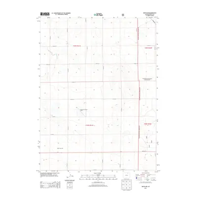
2013 Map of Keota NW
USGS Topo · Published 2013About this map
Pawnee National Grassland dominates the eastern and northern reaches of this high plains landscape in Weld County, Colorado. The terrain is characterized by a high-altitude plateau, rising toward the prominent Seven Cross Hill in the southwest. This 2013 survey illustrates a strictly organized section-line road grid, where routes like Co Road 87 and Co Road 102 define the movement across the prairie. The ephemeral passage of Crow Creek meanders through the western sections, providing one of the few natural breaks in the geometric survey lines. Near the center of the quadrangle, the private William Leon Schawo Airport serves as a remote aviation landmark, while State Hwy 14 cuts across the southern edge, connecting this isolated region to the broader northern Colorado corridor.
Find a feature on this map
25 named features on this map. Tap any name to fly to it.
Don’t see what you’re looking for? This feature index may not catch every label — zoom into the map to look around manually.
Map Details
Editions of this 2013 Keota NW Map
This is the sole edition of this map. No revisions or reprints were ever made.
Other maps of this area

1954 · Greeley
USGS Topo · 1:250,000

1957 · Greeley
USGS Topo · 1:250,000

1958 · Greeley
USGS Topo · 1:250,000

1961 · Greeley
USGS Topo · 1:250,000

1964 · Greeley
USGS Topo · 1:250,000

1965 · Greeley
USGS Topo · 1:250,000

1972 · Dutch Girl Lake
USGS Topo · 1:24,000
1972 · Keota SE
USGS Topo · 1:24,000

1972 · Briggsdale
USGS Topo · 1:24,000

1972 · Keota NW
USGS Topo · 1:24,000