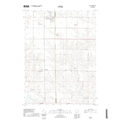
2018 Map of Keota
USGS Topo · Published 2018About this map
The town of Keota sits at the northern edge of this agricultural landscape, straddling the boundary where Keokuk and Washington counties meet. The rectilinear grid of the town, defined by routes like W Keokuk Ave and S Davis St, gives way to a sprawling network of rural section lines and creek drainages. To the south, the smaller settlement of Talleyrand serves as a secondary focal point for the surrounding farms.
Find a feature on this map
62 named features on this map. Tap any name to fly to it.
Don’t see what you’re looking for? This feature index may not catch every label — zoom into the map to look around manually.
Map Details
Editions of this 2018 Keota Map
This is the sole edition of this map. No revisions or reprints were ever made.
Other maps of this area

1954 · Des Moines
USGS Topo · 1:250,000

1956 · Des Moines
USGS Topo · 1:250,000

1957 · Des Moines
USGS Topo · 1:250,000

1958 · Davenport
USGS Topo · 1:250,000

1961 · Davenport
USGS Topo · 1:250,000

1962 · Davenport
USGS Topo · 1:250,000

1965 · Harper
USGS Topo · 1:24,000

1965 · South English
USGS Topo · 1:24,000

1969 · Des Moines
USGS Topo · 1:250,000
1973 · Wellman
USGS Topo · 1:24,000