1957 Map of Kerens
USGS Topo · Published 1958About this map
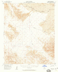
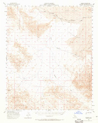
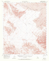
The Union Pacific railroad cuts a vital corridor through the arid basin of the Mojave Desert, connecting remote outposts during the mid-1950s. Small rail stops like Kelso, Glasgow, and Kerens anchor a landscape defined by dramatic shifting sands and isolated peaks. The presence of the Onyx Mine in the Bristol Mountains suggests the area's mineral prospects, while the extensive Devils Playground and Kelso Dunes illustrate the powerful aeolian forces at work in this region. Drainage patterns are clearly marked by ephemeral routes such as Kelso Wash and Budweiser Wash, which direct rare runoff between the Old Dad Mountains and the Granite Mts. A network of Jeep Trails provides the primary means of navigating the desert floor, linking the isolated railroad sidings to the surrounding mountain ranges.
Find a feature on this map
16 named features on this map. Tap any name to fly to it.
Don’t see what you’re looking for? This feature index may not catch every label — zoom into the map to look around manually.
Map Details
Editions of this 1957 Kerens Map
3 editions found
Other maps of this area

1910 · Ivanpah
USGS Topo · 1:250,000

1912 · Ivanpah
USGS Topo · 1:250,000

1933 · Avawatz Mountains
USGS Topo · 1:250,000

1942 · Ivanpah
USGS Topo · 1:250,000

1942 · Amboy
USGS Topo · 1:250,000

1943 · Amboy
USGS Topo · 1:250,000

1947 · Trona
USGS Topo · 1:250,000

1947 · Kingman
USGS Topo · 1:250,000

1948 · Kingman
USGS Topo · 1:250,000

1948 · Trona
USGS Topo · 1:250,000