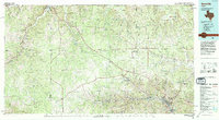
1985 Map of Kerrville
USGS Topo · Published 1994About this map
The Guadalupe River valley serves as a primary hub for development in the eastern portion of this Hill Country study, anchored by the growth of Kerrville and Ingram. In the mid-1980s, the landscape shows a transition from the academic and medical infrastructure of Schreiner College and Sid Peterson Hospital to the remote ranching and hunting grounds of the Blue Mountains. Further west, the headwaters of the Llano River and its forks near Junction define the terrain, where small outposts like Telegraph and Garven Store mark essential junctions in a sparsely populated expanse.
Find a feature on this map
86 named features on this map. Tap any name to fly to it.
Don’t see what you’re looking for? This feature index may not catch every label — zoom into the map to look around manually.
Map Details
Editions of this 1985 Kerrville Map
2 editions found
Other maps of this area

1887 · Llano
USGS Topo · 1:125,000

1887 · Mason
USGS Topo · 1:125,000

1893 · Rock Springs
USGS Topo · 1:125,000

1893 · Fort McKavett
USGS Topo · 1:125,000

1893 · Nueces
USGS Topo · 1:125,000

1894 · Mason
USGS Topo · 1:125,000

1894 · Fredericksburg
USGS Topo · 1:125,000

1894 · Kerrville
USGS Topo · 1:125,000

1894 · Llano
USGS Topo · 1:125,000

1896 · Nueces
USGS Topo · 1:125,000