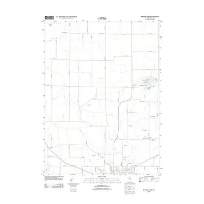
2012 Map of Kewanee North
USGS Topo · Published 2012About this map
Agricultural lands north of Kewanee are defined by a network of drainage systems and rural burial grounds in this early 21st-century survey. The landscape is primarily shaped by the meandering courses of Mud Cr, Walker Cr, and the Edwards River, which cuts through the southwestern corner of the quadrangle. A cluster of recreation areas surrounds Johnson Lake, where several sites including the Chief Keokuk Campground and Chief Black Hawk Picnic Area serve the local community. Genealogists can find several established cemeteries throughout the region, such as the Paco Cem and Garden of Peace Cem, along with the Orthodox Cem and Saint Michael Cem near the southern boundary. The small settlement at Brandenburg Corners remains a notable point of reference within the grid of local roads like Mud Creek Rd and W State Rd.
Find a feature on this map
83 named features on this map. Tap any name to fly to it.
Don’t see what you’re looking for? This feature index may not catch every label — zoom into the map to look around manually.
Map Details
Editions of this 2012 Kewanee North Map
This is the sole edition of this map. No revisions or reprints were ever made.
Other maps of this area

1929 · Annawan
USGS Topo · 1:62,500

1931 · Galva
USGS Topo · 1:48,000

1932 · Annawan
USGS Topo · 1:62,500

1934 · Geneseo
USGS Topo · 1:62,500

1940 · Galva
USGS Topo · 1:62,500

1944 · Galva
USGS Topo · 1:62,500

1944 · Kewanee
USGS Topo · 1:62,500

1953 · German Corner
USGS Topo · 1:24,000
1953 · Galva
USGS Topo · 1:24,000
1953 · Atkinson
USGS Topo · 1:24,000