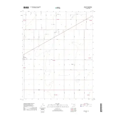
2018 Map of Keyes East
USGS Topo · Published 2018About this map
The town of Keyes occupies the western edge of this Cimarron County landscape, where the street grid of Jackson Ave and Ramsey Blvd meets the vast agricultural sections of the Oklahoma Panhandle. This 2018 survey reveals a highly organized landscape defined by the Public Land Survey System, with roads like N0430 Rd and E0140 Rd following precise section lines across the high plains. In the eastern portion of the quadrangle, the settlement of Burton sits amidst a network of rural routes, while the drainage of Goff Cr provides a rare break in the flat terrain in the northeast. The map provides a detailed view of the region's transport infrastructure, including the diagonal path of a railroad line cutting across the township boundaries of t5n r8e and t4n r8e, illustrating the historical importance of rail in connecting these isolated grain-producing communities.
Find a feature on this map
34 named features on this map. Tap any name to fly to it.
Don’t see what you’re looking for? This feature index may not catch every label — zoom into the map to look around manually.
Map Details
Editions of this 2018 Keyes East Map
This is the sole edition of this map. No revisions or reprints were ever made.
Other maps of this area

1954 · Dalhart
USGS Topo · 1:250,000

1958 · Dalhart
USGS Topo · 1:250,000

1962 · Dalhart
USGS Topo · 1:250,000

1971 · Griggs NE
USGS Topo · 1:24,000

1971 · Sturgis
USGS Topo · 1:24,000

1971 · Keyes West
USGS Topo · 1:24,000

1971 · Hopkins
USGS Topo · 1:24,000

1971 · Keyes NE
USGS Topo · 1:24,000

1971 · Sampsel Lake
USGS Topo · 1:24,000

1971 · Keyes East
USGS Topo · 1:24,000