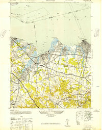
1947 Map of Keyport
USGS Topo · Published 1947About this map
Raritan Bay dominates the northern shoreline of this mid-century survey, where the industrial and residential development of Monmouth County is clearly visible. The coastal corridor is defined by the New York and Long Branch RR and the Jersey Central Lines, which supported a heavy concentration of manufacturing at the Harrison Van Winkle Manning Iron Works, Craigen Brick Co, and the Keyport Rubber Factory. Inland, the landscape transitions from these dense industrial centers in Keyport and Matawan to an area of named family farms, such as Willow Brook Farm and Indian River Farm.
Find a feature on this map
76 named features on this map. Tap any name to fly to it.
Don’t see what you’re looking for? This feature index may not catch every label — zoom into the map to look around manually.
Map Details
Editions of this 1947 Keyport Map
This is the sole edition of this map. No revisions or reprints were ever made.
Other maps of this area

1888 · Plainfield
USGS Topo · 1:62,500

1888 · New Brunswick
USGS Topo · 1:62,500

1888 · Sandy Hook
USGS Topo · 1:62,500

1893 · New Brunswick
USGS Topo · 1:62,500

1893 · Plainfield
USGS Topo · 1:62,500
1893 · Sandy Hook
USGS Topo · 1:62,500
1898 · Plainfield
USGS Topo · 1:62,500
1898 · Staten Island
USGS Topo · 1:62,500
1900 · Passaic
USGS Topo · 1:125,000
1900 · Staten Island
USGS Topo · 1:62,500