
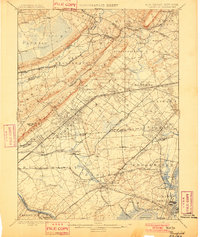
1898 Map of Plainfield
USGS Topo · Published 1898About this map
Great Swamp and the ridges of First Mountain and Second Mountain dominate the topography of this late 19th-century landscape, revealing a region transitioning from agrarian roots to a dense suburban and industrial corridor. The map highlights the early development of established communities like Chatham, Summit, and Millburn, while also documenting smaller locales such as Feltville and Locust Grove. The intricate network of the Central Railroad of New Jersey and the Morris and Essex Division of the DL&W illustrates how rail connectivity began to shape the residential patterns of Union and Essex counties. From the marshy reaches of Dismal Swamp to the upland slopes of Baltusrol, the survey records the local stream systems, including Ambrose Brook and the Rahway River, before the expansive suburban infill of the 20th century altered the drainage and property lines of these historic townships.
Find a feature on this map
111 named features on this map. Tap any name to fly to it.
Don’t see what you’re looking for? This feature index may not catch every label — zoom into the map to look around manually.
Map Details
Editions of this 1898 Plainfield Map
2 editions found
Other maps of this area

1888 · Plainfield
USGS Topo · 1:62,500

1888 · Morristown
USGS Topo · 1:62,500

1888 · New Brunswick
USGS Topo · 1:62,500

1888 · Princeton
USGS Topo · 1:62,500

1888 · Lake Hopatcong
USGS Topo · 1:62,500

1888 · Paterson
USGS Topo · 1:62,500

1888 · Sandy Hook
USGS Topo · 1:62,500

1891 · Somerville
USGS Topo · 1:62,500

1892 · Paterson
USGS Topo · 1:62,500

1893 · New Brunswick
USGS Topo · 1:62,500