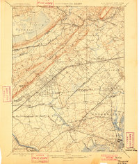
1898 Map of Plainfield
USGS Topo · Published 1901About this map
Watchung Mountains define the northern topography of this 19th-century New Jersey landscape, creating a dramatic barrier between the developing rail corridors to the south and the sprawling Great Swamp to the north. Surveyed in 1887, this map illustrates the dense network of townships and early suburban settlements before the mid-century industrial boom. A complex system of transit is visible, dominated by the Central Railroad of New Jersey and the Lehigh Valley Railroad, which facilitated the growth of places like Scotch Plains and Summit.
Find a feature on this map
136 named features on this map. Tap any name to fly to it.
Don’t see what you’re looking for? This feature index may not catch every label — zoom into the map to look around manually.
Map Details
Editions of this 1898 Plainfield Map
2 editions found

Other maps of this area

1888 · Plainfield
USGS Topo · 1:62,500

1888 · Morristown
USGS Topo · 1:62,500

1888 · New Brunswick
USGS Topo · 1:62,500

1888 · Princeton
USGS Topo · 1:62,500

1888 · Lake Hopatcong
USGS Topo · 1:62,500

1888 · Paterson
USGS Topo · 1:62,500

1888 · Sandy Hook
USGS Topo · 1:62,500

1891 · Somerville
USGS Topo · 1:62,500

1892 · Paterson
USGS Topo · 1:62,500

1893 · New Brunswick
USGS Topo · 1:62,500