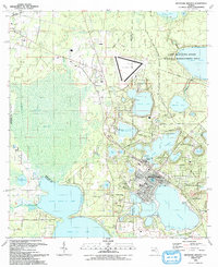
1993 Map of Keystone Heights
USGS Topo · Published 1993About this map
Keystone Heights serves as the central hub of this North Florida landscape, surrounded by an intricate chain of lakes and wetlands at the junction of Clay, Bradford, and Alachua counties. The community's development is closely tied to its water features, with the Park of the Palms and Keystone Beach Park bordering Lake Geneva. To the north, the Camp Blanding Military Reservation boundary and the Camp Blanding State Wildlife Management Area represent significant conservation and military land use, while the triangular Keystone Airpark stands out as a major landmark near Theressa.
Find a feature on this map
78 named features on this map. Tap any name to fly to it.
Don’t see what you’re looking for? This feature index may not catch every label — zoom into the map to look around manually.
Map Details
Editions of this 1993 Keystone Heights Map
This is the sole edition of this map. No revisions or reprints were ever made.
Other maps of this area

1915 · Interlachen
USGS Topo · 1:48,000

1916 · Interlachen
USGS Topo · 1:62,500

1938 · Hawthorn
USGS Topo · 1:48,000

1941 · Starke
USGS Topo · 1:62,500

1942 · Ates Creek
USGS Topo · 1:62,500

1943 · Hawthorn
USGS Topo · 1:62,500

1944 · Interlachen
USGS Topo · 1:62,500

1948 · Starke
USGS Topo · 1:50,000

1949 · Sampson
USGS Topo · 1:24,000

1949 · Gold Head Branch
USGS Topo · 1:24,000