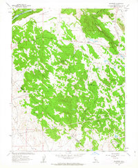
1962 Map of Keystone
USGS Topo · Published 1963About this map
Table Mountain and the Stanislaus River anchor this topographic study of the foothills where Tuolumne, Calaveras, and Stanislaus Counties converge. The landscape is defined by the massive infrastructure of the Hetch Hetchy Aqueduct carving across the center of the sheet, while the northern edge is dominated by Tulloch Dam. This era shows a working ranching and forestry landscape, noted by the Kistler Ranch and Burgeson Ranch, alongside a California Division of Forestry station near Keystone. The terrain is marked by the prominent Rushing Mountain lookout and the distinctive Red Hills, with the Sierra Road providing a primary transit corridor through the drainage basins of Dry Creek and North Fork Wildcat Creek. Isolated prospects and a claypit suggest the localized mineral interests that persisted into the early 1960s.
Find a feature on this map
34 named features on this map. Tap any name to fly to it.
Don’t see what you’re looking for? This feature index may not catch every label — zoom into the map to look around manually.
Map Details
Editions of this 1962 Keystone Map
2 editions found
Other maps of this area

1893 · Sonora
USGS Topo · 1:125,000

1896 · Sonora
USGS Topo · 1:125,000

1897 · Sonora
USGS Topo · 1:125,000

1898 · Sonora
USGS Topo · 1:125,000

1915 · Paulsell
USGS Topo · 1:31,680

1915 · La Grange
USGS Topo · 1:24,000

1916 · Cooperstown
USGS Topo · 1:31,680

1916 · Copperopolis
USGS Topo · 1:62,500

1919 · La Grange
USGS Topo · 1:31,680

1942 · Copperopolis
USGS Topo · 1:62,500