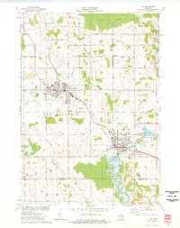
1974 Map of Kiel
USGS Topo · Published 1977About this map
The industrial and agricultural corridor between New Holstein and Kiel is the focal point of this mid-1970s survey. The landscape is defined by the Chicago Milwaukee St Paul and Pacific railroad, which links these manufacturing hubs through a patchwork of dairy country. The importance of local industry is evident in the numerous Gravel Pits, a Quarry, and the Kilns located along Lime Kiln Road.
Find a feature on this map
64 named features on this map. Tap any name to fly to it.
Don’t see what you’re looking for? This feature index may not catch every label — zoom into the map to look around manually.
Map Details
Editions of this 1974 Kiel Map
This is the sole edition of this map. No revisions or reprints were ever made.
Other maps of this area

1954 · School Hill
USGS Topo · 1:24,000

1954 · Howards Grove
USGS Topo · 1:62,500

1954 · Chilton
USGS Topo · 1:62,500

1954 · Reedsville
USGS Topo · 1:62,500

1954 · Franklin
USGS Topo · 1:24,000

1954 · Kiel
USGS Topo · 1:62,500

1954 · Milwaukee
USGS Topo · 1:250,000

1954 · Manitowoc
USGS Topo · 1:250,000

1955 · Green Bay
USGS Topo · 1:250,000

1957 · Madison
USGS Topo · 1:250,000